Global Environmental Zones Explorer
Visualize Agroclimatic Zonations & Their Relationships to CFT Locations
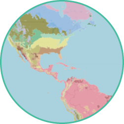
View Maps of Crop Distribution
to find out where selected crops are cultivated globally across agroclimatic zones.
Generate
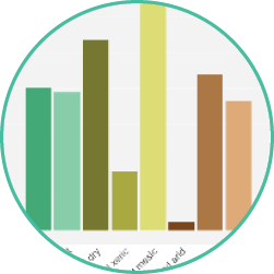
Crop Histograms
showing the distribution of selected crops across agroclimatic zones at different geographic scales.
Explore
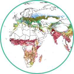
Agroclimatic Zones
by clicking on an interactive map or entering geographic coordinates.
The Database
The Agriculture & Food Systems Institute’s Global Environmental Zones (GEnZ) Explorer is a simple-to-use online tool that allows users to visualize agroclimatic zonations and their relationships to CFT locations. For any of the 20 included crops, the tool can identify environments at the country, regional, or global level that are important for cultivation to help determine where to best locate CFTs and maximize data utility.
The Need
Confined field trials (CFTs) are conducted to inform environmental risk assessments that are required by regulatory authorities before genetically engineered crops can be approved and released for cultivation. The primary variable that differentiates CFT locations is agroclimate, which means that data from trials cultivated in like agroclimates should be considered relevant and sufficient to satisfy regulatory requirements for CFT data, irrespective of the country where the CFTs are conducted.
Log In
Free, easy registration to access the AFSI e-learning portal, WNDDS map tool, and GEnZ Explorer. Separate registration for other linked resources may be required.